WangLibo1995/GeoSeg
Satellite segmentation with a transformer upgrade
GeoSeg bundles modern vision transformers and CNNs into a single PyTorch Lightning pipeline for aerial and satellite imagery.
Not currently ranked — collecting fresh signals.
star history
What it does
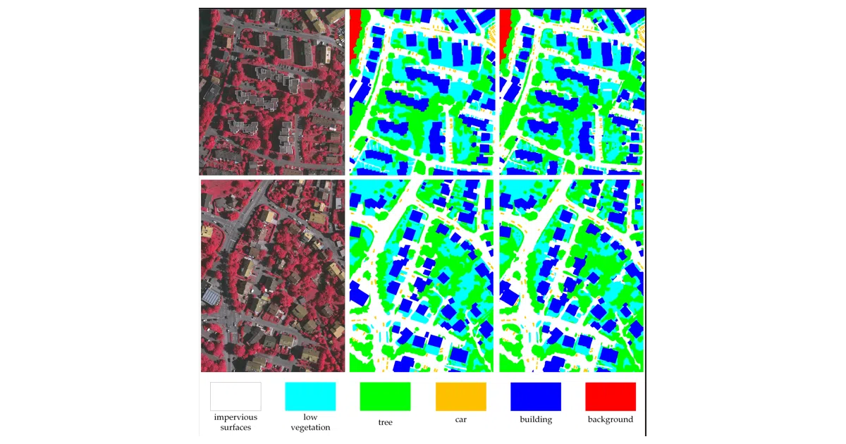
GeoSeg is a semantic segmentation toolbox built specifically for remote sensing—urban aerial shots, drone footage, and satellite passes. It wraps a unified training pipeline around PyTorch Lightning and timm, letting you benchmark CNNs like MANet against Vision Transformers such as UNetFormer or DC-Swin without rewriting boilerplate. The repo includes dataset adapters for ISPRS Vaihingen, Potsdam, UAVid, LoveDA, and OpenEarthMap, plus sliding-window inference for tiles too large to load into GPU memory at once.
The interesting bit
The project’s own UNetFormer (published in ISPRS) keeps a UNet-like encoder-decoder but swaps in transformer blocks, and the recent addition of PyramidMamba shows the maintainers are tracking the state-space model wave. Most academic code stops at a test script; this one actually ships tooling to chop up and reason over “huge” remote sensing images, which is where real-world deployment lives.
Key highlights
- Ships UNetFormer, DC-Swin, BANet, and CNNs (MANet, ABCNet, A2FPN) under one benchmark script
- Built on PyTorch Lightning 2.0 and
timm, so multi-GPU training and backbone swaps are mostly config-driven - Includes patch-splitting utilities and sliding-window inference for oversized aerial tiles
- Provides pretrained backbone weights via Google Drive and Baidu Disk
- Reproduction tables for standard remote-sensing benchmarks are included
Caveats
- Dataset preparation is strictly DIY: you must download raw imagery from official portals and run the provided patch-splitting scripts yourself
- Architectural intuition is left to the linked papers; the README is heavy on execution examples and light on model explanations
- Mamba support depends on additional packages not covered by the base requirements file
Verdict
Grab it if you need a unified remote-sensing segmentation benchmark that covers both CNNs and transformers. Look elsewhere if you want a batteries-included dataset or a general-purpose segmentation framework.
Frequently asked
- What is WangLibo1995/GeoSeg?
- GeoSeg bundles modern vision transformers and CNNs into a single PyTorch Lightning pipeline for aerial and satellite imagery.
- Is GeoSeg open source?
- Yes — WangLibo1995/GeoSeg is open source, released under the GPL-3.0 license.
- What language is GeoSeg written in?
- WangLibo1995/GeoSeg is primarily written in Python.
- How popular is GeoSeg?
- WangLibo1995/GeoSeg has 1.1k stars on GitHub.
- Where can I find GeoSeg?
- WangLibo1995/GeoSeg is on GitHub at https://github.com/WangLibo1995/GeoSeg.